
Pakistan’s weather shifted noticeably between Wednesday, Jan 21, and Thursday, Jan 22, 2026, as a new weather system began influencing large parts of the country. After several days of cold and dry conditions, clouds increased and temperatures dipped further, setting the stage for rain, thunderstorms, and snowfall in the days ahead.
On Wednesday (Jan 21), most regions remained dry but chilly. Cold air dominated Punjab, Khyber Pakhtunkhwa, Balochistan, and Sindh, while northern and hilly areas recorded freezing night temperatures. Fog persisted in several plains, especially during early morning and late night hours.
As Thursday begins, weather conditions are expected to turn unsettled across multiple regions.
Balochistan has emerged as one of the hardest-hit regions as the weather system takes hold, with snowfall already reported across several districts since early Thursday.
In Quetta, snowfall began during the early hours of Thursday, pushing temperatures close to freezing and disrupting daily activity. Similar conditions have been reported in Ziarat, Kalat, Mastung, Khanozai, Qila Saifullah, Pishin, and nearby high-altitude areas, where snow accumulation has intensified the winter chill.
برفباری سے وادی زیارت کا خوبصورت منظر، بلوچستان pic.twitter.com/SU4WVY7L8b
— Pakistan Tourism (@PakistanJannatt) January 22, 2026
Snowfall has also spread across large parts of northern and western Balochistan, including Zhob, Sherani, Loralai, Barkhan, Muslim Bagh, and adjoining mountainous belts. In these regions, snow-covered roads and cold winds have significantly reduced visibility and slowed traffic.
Meanwhile, cold conditions dominate the rest of the province, with strong winds and sharply falling night temperatures reported in central and southern districts. Residents in several areas have been advised to exercise caution, particularly while travelling through hilly terrain, as icy patches and reduced road grip pose risks.
The snowfall in Balochistan marks one of the earliest widespread winter spells of the season, reinforcing forecasts that the ongoing weather system will continue to impact western and northern Pakistan over the next 24 hours.
اوسی
کوئٹہ اور بلوچستان کے مختلف علاقوں میں سال کی پہلی برف باری ہوئی ہے جس کے باعث سردی کی شدت میں اضافہ ہوا ہے اور نتیجے میں بجلی کی انکھ مچولی بھی شروع ہوچکی ہے تاہم پی ڈی ایم اے اور نیشنل ہائی وے اتھارٹی کی جانب سے قومی شاہراہوں کو کھولنے کے لیے اقدامات جاری ہیں pic.twitter.com/wHVSxHKRnm— Daily Khabardar Quetta (@KhabardarDaily) January 22, 2026
Weather activity is also expected to reach Sindh. In Karachi, weather conditions are expected to change noticeably from Thursday as moisture-laden clouds move in from the Arabian Sea. Light to moderate rain accompanied by thunderstorms is likely, particularly during the late afternoon, evening, and overnight hours. Brief but intense showers may occur in some localities, with the possibility of isolated lightning and gusty winds during thunderstorm activity.
Rain chances are expected to be higher in coastal and central districts, while eastern and northern parts of the city may see shorter, scattered spells. The change in weather is likely to lower daytime temperatures, bringing a cooler feel compared to recent dry days. Night temperatures may dip further, especially after rainfall.
Humidity levels are forecast to rise ahead of the rain, which could make conditions feel colder once showers begin. Strong winds during thunderstorms may temporarily reduce visibility, particularly along coastal roads and open areas.
Looking ahead to Friday (Jan 23), Karachi may continue to see intermittent rain or drizzle, though intensity is expected to ease compared to Thursday. Cloudy skies are likely to persist through much of the day, with breaks possible later in the evening. Sea conditions may remain slightly rough during periods of stronger winds.
Residents are advised to remain cautious during rainfall, as water accumulation on roads, slippery surfaces, and sudden gusts could affect traffic flow, especially during peak commuting hours.
In Punjab, rain and thunderstorms are likely in Islamabad, Rawalpindi, Lahore, Gujranwala, Sialkot, Faisalabad, Sargodha, Multan, Sahiwal, Okara, and Bahawalpur. Intermittent showers may continue through the day, with brief dry spells in between.
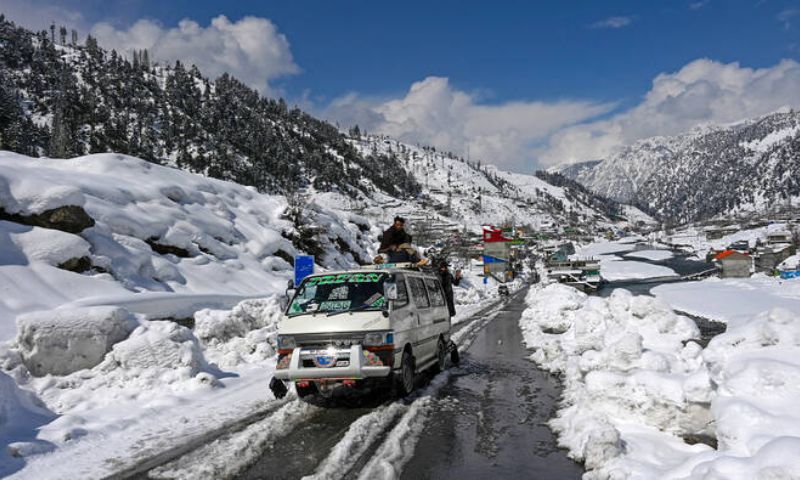
Khyber Pakhtunkhwa is expected to see rain in Peshawar, Mardan, Charsadda, Swabi, Abbottabad, Mansehra, Haripur, Kohat, and Bannu, while snowfall is likely in upper areas including Swat, Kalam, Dir, Chitral, Shangla, Kohistan, and Upper Chitral.
In Gilgit-Baltistan, snowfall is expected in Skardu, Hunza, Astore, Gilgit, Ghanche, and surrounding high-altitude valleys, which could affect travel on mountainous routes.
By Friday, the weather system is forecast to intensify, bringing heavier snowfall to Murree, Galiyat, Neelum Valley, Bagh, Haveli, Poonch, Naran, and Kaghan. Rain is expected to continue across upper and central Punjab, while Sindh and southern Punjab may see scattered showers and thunderstorms, mainly during afternoon and evening hours.
Temperatures are forecast to remain below normal, with cold nights and brisk winds persisting nationwide.
Overall, Pakistan is set to experience a significant mid-winter weather shift, moving from dry cold to widespread rain and snow between Jan 22 and Jan 23, with impacts varying sharply by region.